Roseville Transit Preferred Service Plan
Overview:
Roseville is moving forward with significant changes to its public transit system as part of the Transportation 360 initiative. On November 19, the Transportation Commission and Roseville Transit approved the preferred service plan, which includes updates to the citywide Arrow on-demand service and a reconfiguration of bus routes to enhance the transit experience, promote sustainable urban mobility, and support data-driven decision-making in transit planning.
The phased implementation plan for Roseville Transit ensures a flexible and adaptable approach to rolling out the new service structure. This malleable framework allows the City to evaluate each phase of implementation, incorporating public and commission feedback to make necessary adjustments before moving forward. By involving the community and stakeholders throughout the process, the plan ensures that changes are responsive to rider needs and operational realities, resulting in a transit system that evolves effectively over time. Each phase will be reviewed and approved in collaboration with the public and the Transportation Commission, maintaining transparency and alignment with the City’s goals.
Your feedback remains crucial as we refine the plan before it goes to the City Council for final approval in January. Please review the maps and provide your comments to help shape the future of transit in Roseville.
Why Changes Are Being Considered:
- Population Growth: Roseville has experienced a substantial population increase of 23.8% from 2011 to 2021, necessitating improvements in public transit to accommodate growing demand.
- Work-from-Home Trends: High levels of remote work in Placer County have affected commuter ridership, creating a need for more flexible and efficient transit solutions.
- Public Feedback: Extensive public input through surveys and community events highlighted the need for better transit services tailored to the citys evolving needs.
Project Goals:
- Elevate the Transit Experience:
Improve service quality and reliability to attract more riders. - Improve Transit Access:
Encourage residents to choose public transit over personal vehicles, reducing traffic and environmental impact. - Foster Sustainable Urban Mobility:
Support sustainable transportation options to enhance the city’s livability and environmental health. - Enhance Data-Driven Decision-Making in Transit Planning:
Use comprehensive data collection and analysis to inform and optimize transit service planning.
Benefits to Riders:
- Improved Service Efficiency:
Specific Arrow zones allow more efficient routing and scheduling, reducing wait times and improving punctuality. -
Enhanced Connectivity:
Riders can travel within their zones without transfers and connect seamlessly to local routes for inter-zone travel. Often at a lower cost. - More buses per hour:
Most Local routes running every 30 minutes provide frequent and reliable service. - Focused Service Areas:
Services are concentrated in high-demand areas, optimizing resource allocation and improving service quality. - Retained ADA-Paratransit Services:
ADA-Paratransit eligible customers continue to have city-wide travel access as before.
Please leave a comment:
Preferred Service Plan
Roseville’s Preferred Service Plan, approved as part of the Transportation 360 initiative, brings transformative changes to the city’s public transit system. The plan introduces new services like the high-frequency Rapid Link and zonal Arrow On-Demand service, expands route coverage, and improves connections to key destinations such as medical centers and employment hubs. With a focus on sustainability, the plan integrates electric vehicles and modernized transit options, all designed to enhance the rider experience, reduce wait times, and support Roseville’s growing community. Your feedback is vital as we refine the plan ahead of City Council review in January.
Why We Chose the Preferred Service Plan
- Community Feedback: Reflects insights from extensive public engagement to address rider needs, preferences, and barriers.
- Adaptability to Growth: Supports Roseville’s rapid population growth and suburban development with expanded and flexible transit options.
- Sustainability Goals: Aligns with Roseville’s environmental initiatives by integrating electric vehicles and reducing emissions.
- Data-Driven Decision-Making: Based on detailed travel pattern analysis and ridership trends to ensure effective service design.
Benefits of the Preferred Service Plan
- Enhanced Accessibility: Expands service to underserved areas, including new residential and commercial developments.
- Increased Frequency: Reduces wait times with 30-minute service on Local routes and frequent Commuter and Rapid Link services during peak hours.
- Improved Connectivity: Adds direct connections to medical centers, employment hubs, and regional transit, reducing transfer needs.
- Flexibility for Riders: Introduces zonal Arrow on-demand services to offer convenient, point-to-point travel options.
- Sustainability: Includes electrification of the fleet, starting with the new Rapid Link service, and modernized vehicles to reduce emissions and costs.
Major Changes in the Preferred Service Plan
Service Expansion:
- Introduction of the Rapid Link Service: High-frequency, limited-stop routes connecting residential areas to Sacramento employment centers.
- Expansion of Arrow On-Demand Zones: Improves service to low-density areas with flexible, efficient transit.
Route Redesign:
- Reduced service overlap for more efficient coverage.
- Simplified route structures to include bi-directional services on all Local routes.
Frequency Enhancements:
- Local buses to run every 30 minutes (except Route 2 at 60 minutes).
- Commuter service focused on express trips during peak hours to Downtown Sacramento.
Electrification:
- Full electrification of the Rapid Link fleet and gradual integration of electric vehicles across all services.
- Installation of charging infrastructure at key hubs like the Galleria Transit Hub.
Fare Adjustments:
- Align Arrow fares with Local service fares to improve affordability and equity.
- Eliminate underutilized multi-ride passes to streamline fare options.
This comprehensive plan ensures Roseville Transit evolves into a sustainable, efficient, and rider-focused system.
Please Leave a Comment
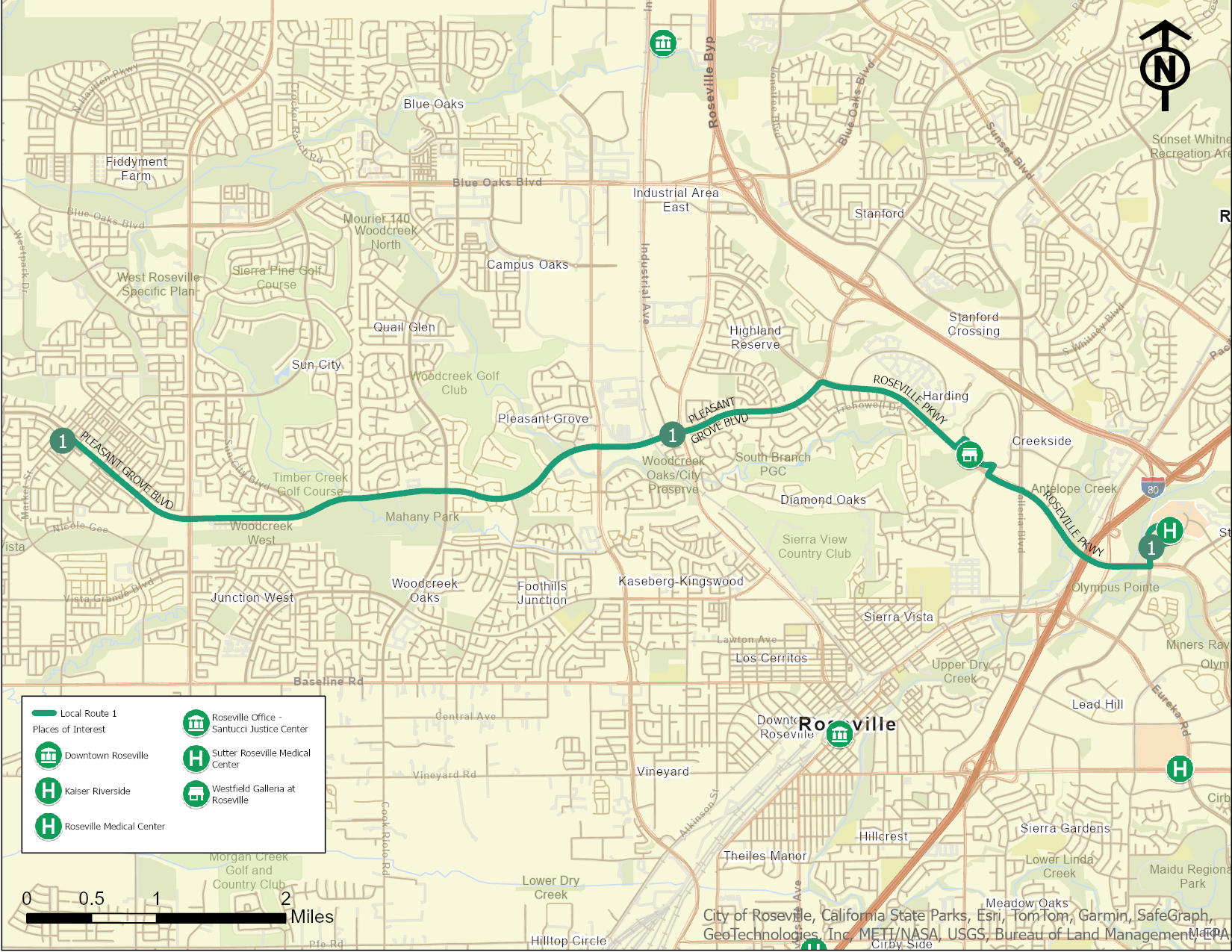
Local Route 1
Local Route 1 connects West Roseville’s Junction West neighborhood to key destinations across the city, including the Roseville Medical Center, Kaiser Riverside, Sutter Roseville Medical Center, and Downtown Roseville. Running along major corridors such as Pleasant Grove Boulevard and Roseville Parkway, this route ensures direct and reliable access to critical services, shopping hubs like the Westfield Galleria, and employment centers. With bi-directional service and stops at Mahany Park and other community landmarks, Route 1 offers an essential link for residents and visitors alike.
Major Destinations Served: Roseville Galleria, Sutter Roseville Medical Center
Transfer Points: Connections are available at Downtown Roseville for routes 2, 3, and 4 and at Roseville Galleria for routes 3 and 4.
Frequency and Span of Service: 30 minutes from 7:00 am to 9:00 pm
Please Leave a Comment
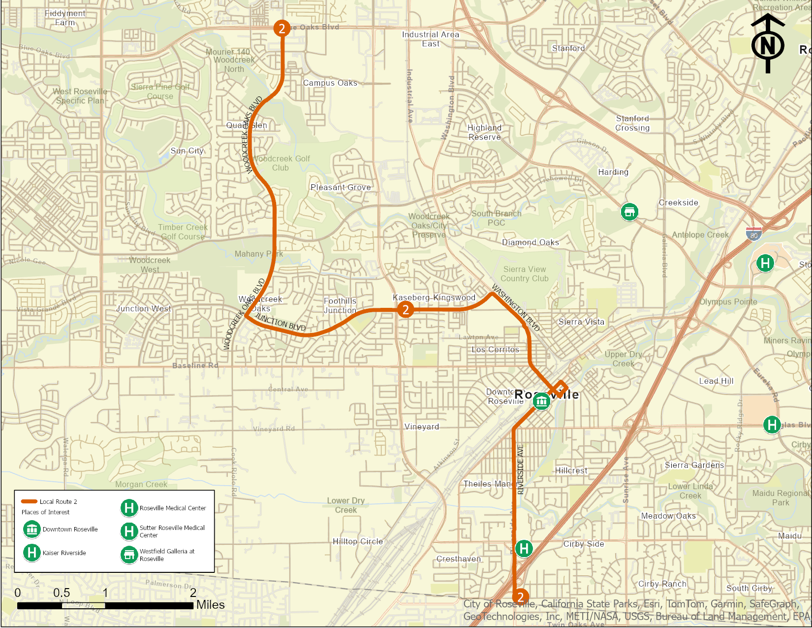
Local Route 2
Local Route 2 provides critical connections from the Woodcreek Oaks and Campus Oaks neighborhoods to key destinations such as Downtown Roseville, Kaiser Riverside, and the Louis Orlando Transit Center. The route travels along major corridors including Woodcreek Oaks Boulevard and Washington Boulevard, offering reliable service to residential areas, community parks, and key commercial hubs. With direct stops at vital medical and shopping centers, Route 2 ensures convenient access for riders traveling for healthcare, work, or recreation.
Major Destinations Served: Downtown Roseville, Kaiser Riverside, Louis Orlando Transit Center
Transfer Points: Connections available at Downtown Roseville for routes 3 and 4
Frequency and Span of Service: Every 60 minutes from 7:00 am to 9:00 pm
Please leave a comment
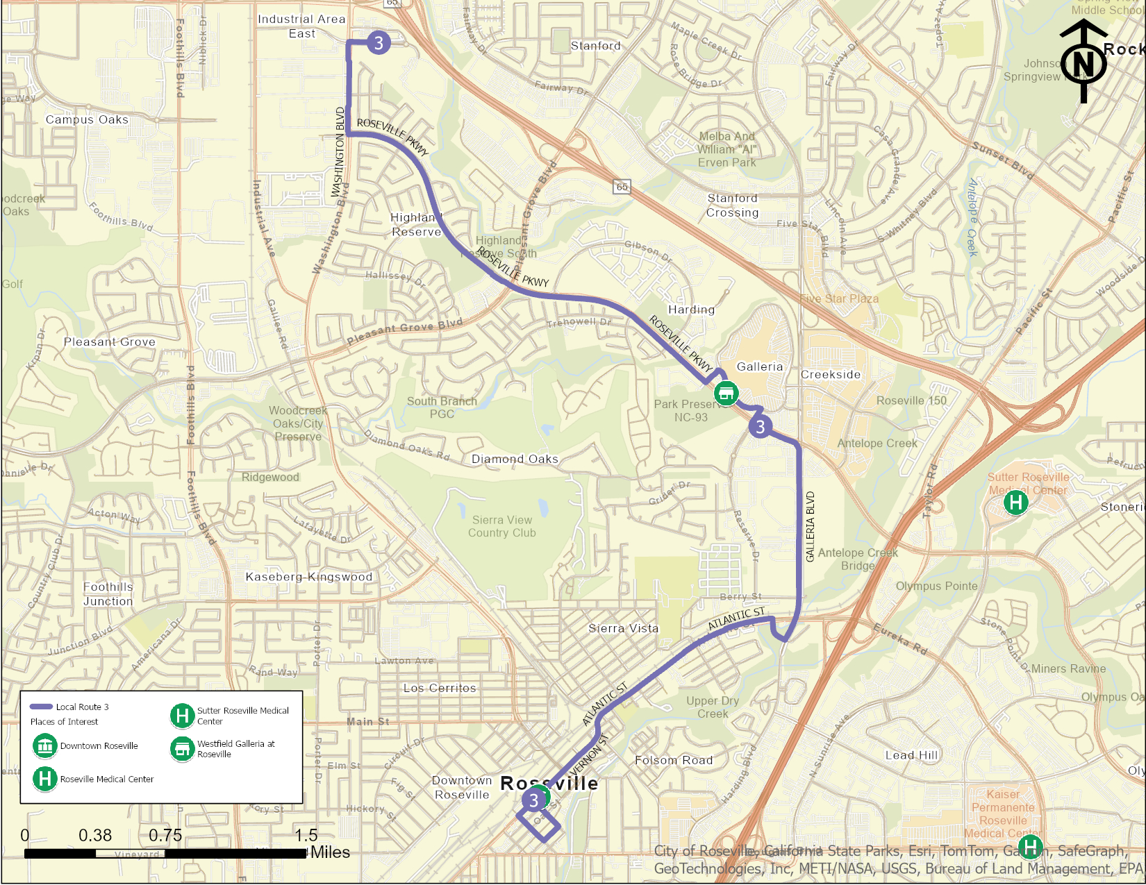
Local Route 3
Local Route 3 connects Downtown Roseville to key destinations such as the Westfield Galleria. Traveling along major corridors like Roseville Parkway and Galleria Boulevard, this route provides essential access to high-demand areas including shopping centers, and residential neighborhoods. With transfer opportunities to other routes at the Galleria Transit Hub and Downtown Roseville, Route 3 serves as a critical link for riders seeking regional connectivity and reliable transit options for daily needs.
Major Destinations Served: Roseville Galleria, Downtown Roseville
Transfer Points: Connections available to Route 2 in Downtown Roseville and Routes 1, 4, and 5 at the Roseville Galleria
Frequency and Span of Service: Every 30 minutes from 7:00 am to 9:00 pm
Please Leave a Comment
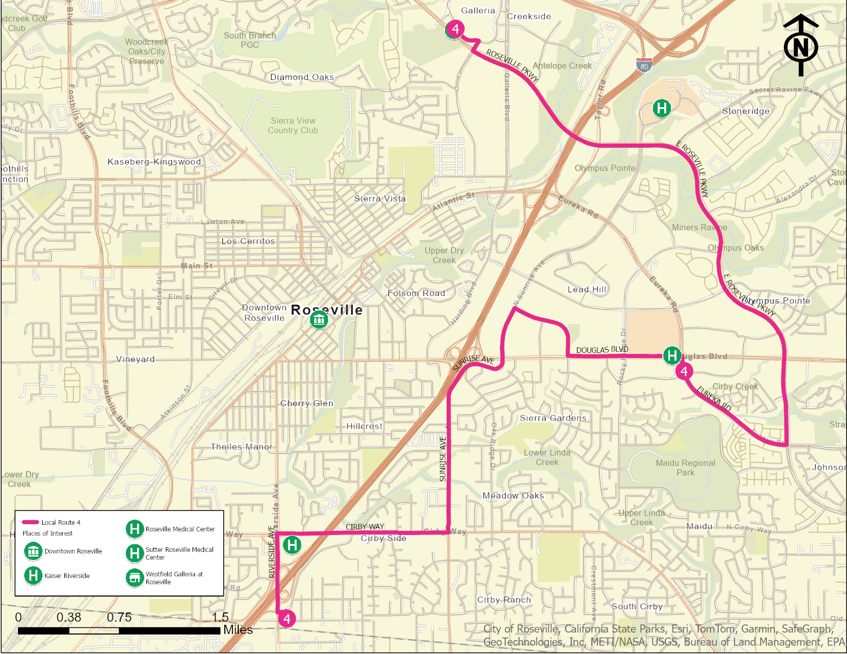
Local Route 4
Local Route 4 connects Downtown Roseville with residential neighborhoods, major shopping destinations, and healthcare facilities. Key stops include the Westfield Galleria, Kaiser Riverside, and Sutter Roseville Medical Center, with transfer opportunities at the Galleria Transit Hub. Traveling along Douglas Boulevard and Roseville Parkway, the route ensures reliable service to high-demand areas, including employment and commercial hubs. Route 4 provides essential connections for riders seeking transit options for daily commutes, medical appointments, and leisure activities.
Major Destinations Served: Kaiser Roseville Medical Center, Kaiser Riverside, Louis Orlando Transit Center
Transfer Points: Connections available at the Roseville Galleria for routes 1, 3, and 5, and at Louis Orlando Transit Center for routes 2 and 3
Frequency and Span of Service: Every 30 minutes from 7:00 am to 9:00 pm
Please Leave a Comment
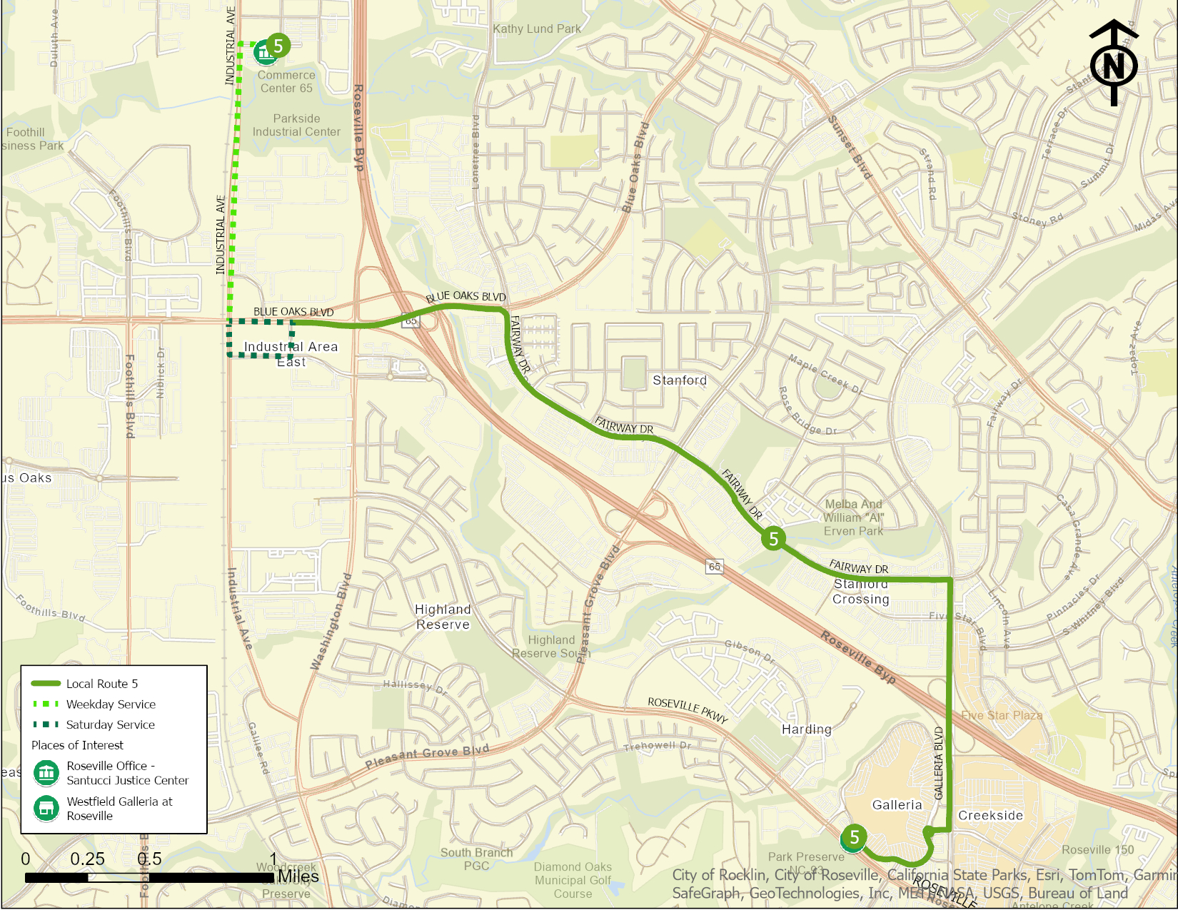
Local Route 5
Local Route 5 connects the Westfield Galleria to key employment and government destinations, including the Santucci Justice Center and industrial areas along Blue Oaks Boulevard and Industrial Avenue. On weekdays, the route ensures riders can reach the Justice Center before it opens at 8:00 a.m. and provides all-day service, supporting commutes and access to business parks. On Saturdays, service excludes the Justice Center as it is closed, focusing instead on other high-demand areas. This route is essential for connecting residential neighborhoods, retail centers, and employment hubs.
Major Destinations Served: Santucci Justice Center, Fairway Dr commercial area, Roseville Galleria
Transfer Points: Connections available at Roseville Galleria for routes 1, 3, and 4
Frequency and Span of Service: All-day service, Monday through Friday
Please Leave a Comment
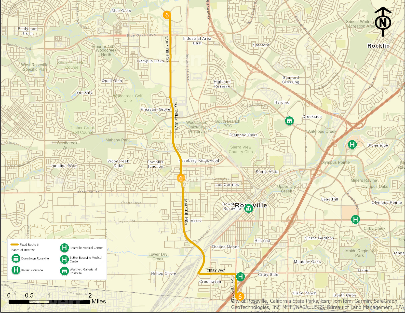
Local Route 6
Local Route 6 serves businesses along Foothills Blvd, including Pride Industries, and ends at the Louis Orlando Transit Center. The route primarily travels along Foothills Blvd, offering access to industrial areas and employment centers. This route is designed to support commuters during peak hours, with service available only on weekdays. It is ideal for connecting workers in the northern industrial areas to the central transit hubs.
Major Destinations Served: Pride Industries, Louis Orlando Transit Center
Transfer Points: Connections available at Louis Orlando Transit Center for routes 2 and 4
Frequency and Span of Service: Peak hours only, weekdays
Please Leave a Comment
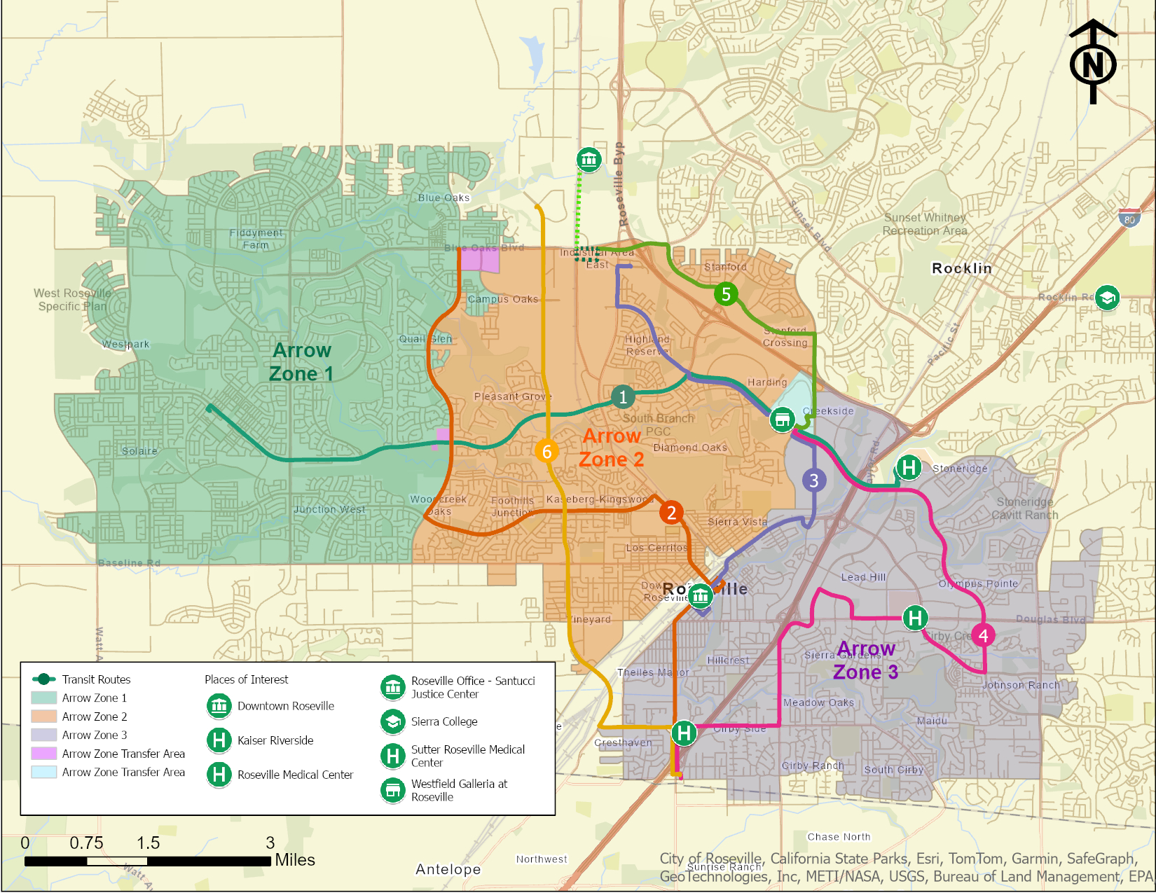
Arrow Zones and Local Route Integration
The new Arrow Zones divide the city into three distinct service areas, designed to provide faster, more efficient microtransit options by reducing wait times and shortening travel durations. This targeted approach replaces the previous citywide on-demand service, focusing on improving connectivity within each zone and guiding riders to transfer seamlessly to local routes for longer-distance trips along main transit corridors. Roseville Transit is also working with PCTPA to incorporate certain parts of Granite Bay into the Arrow service. While an agreement is not yet finalized, the plan envisions that riders from Granite Bay would have access to Roseville with weekday service during key parts of the day, further enhancing regional mobility and accessibility.
Arrow Zone 1:
Geographical Coverage:
Western part of the city, encompassing areas around Pleasant Grove Blvd, Blue Oaks Blvd, and West Park Drive.
- Local Route Connections:
Transfers to Local Routes 1 and 2. - Key Transfer Points: Pleasant Grove Blvd, Woodcreek Oaks Blvd (Local Route 2), and Junction Blvd (Local Route 1).
Arrow Zone 2:
- Geographical Coverage:
Central part of the city, including areas around Foothills Blvd and Baseline Rd. - Local Route Connections:
- Transfers to Local Routes 1, 2, 3, 4, 5, and 6.
- Key Transfer Points: Foothills Blvd and Junction Blvd (Local Route 2), Douglas Blvd (Local Route 3) and Galleria.
Arrow Zone 3:
- Geographical Coverage:
Southeast part of the city, including areas around Sunrise Ave and Cirby Way. - Local Route Connections:
- Transfers to Local Routes 2, 3, 4 and 6.
- Key Transfer Points: Sunrise Ave and Cirby Way (Local Route 4), Douglas Blvd and Sunrise Ave (Local Route 1 and 6).
ADA-Paratransit Services
ADA-Paratransit eligible customers will continue to have access to city-wide travel as per current practices without the need for transfers.
Please Leave a Comment
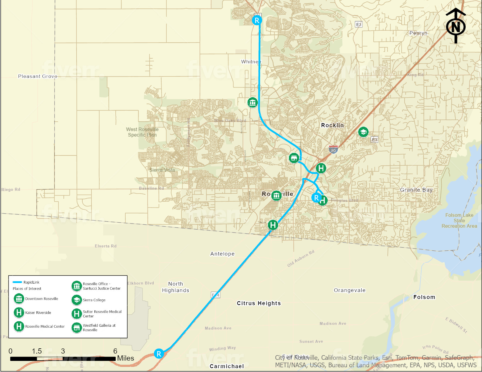
Rapid Link
Roseville Transit is proposing to alter Commuter Services as well. The first draft change would include a new service known as “Rapid Link” connecting Lincoln with the Galleria, Sutter Health, Kaiser Roseville, with the Watt/I-80 Blue Line rail station. The service would run all day every 30 minutes between Lincoln and the light rail station.
Start Point: Lincoln
End Point: Watt/I-80 Rail Station
Major Roads Traversed: Highway 65, Galleria Blvd, Roseville Pkwy
Major Destinations Served: Roseville Galleria, Sutter Roseville Medical Center, Roseville Medical Center
Transfer Points: Connections available at Roseville Galleria and Downtown Roseville for local routes
Frequency and Span of Service: Weekdays only, every 30 minutes from 7:00 am to 7:00 pm
Please Leave a Comment
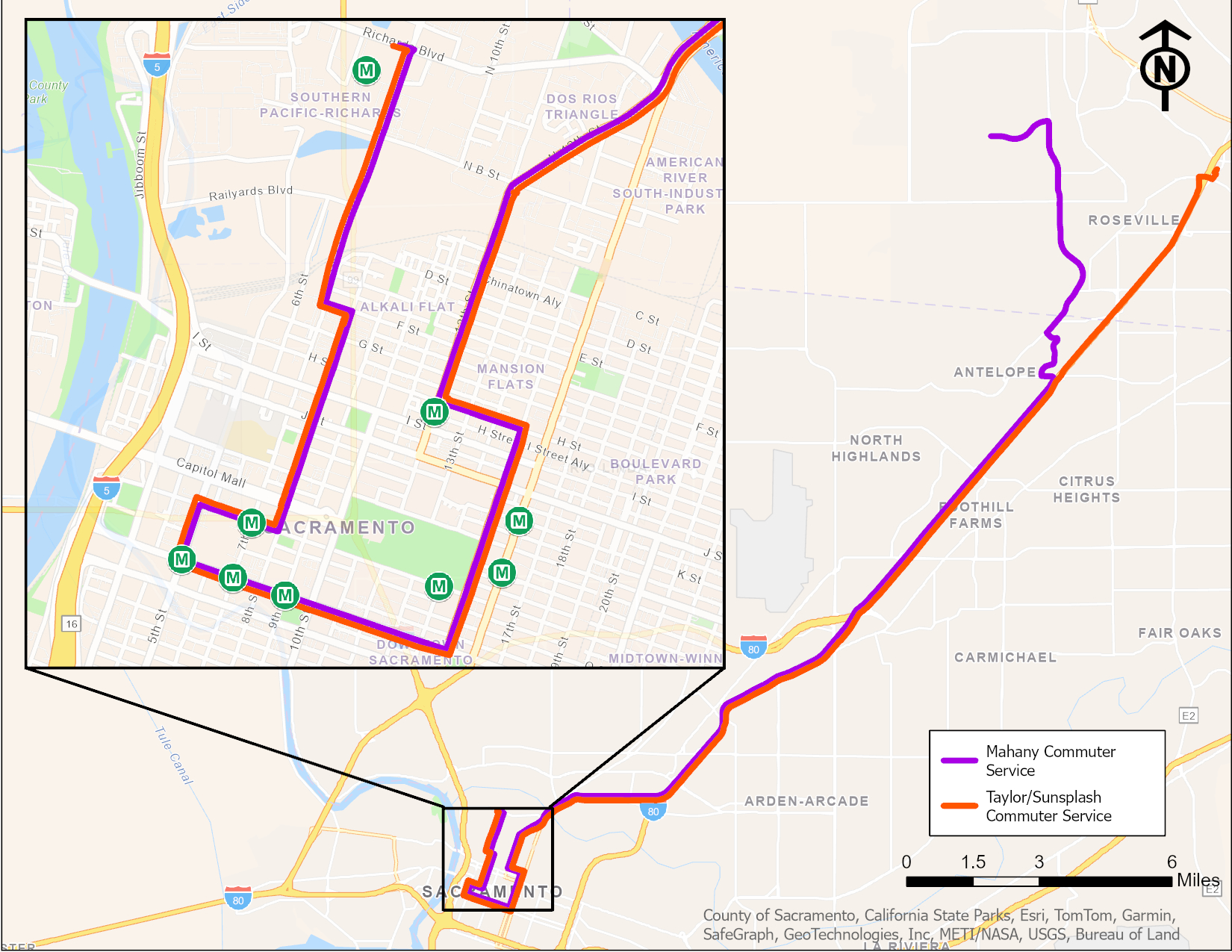
Commuter Services
The redesigned commuter services streamline access to Downtown Sacramento with four trips departing from the Taylor Road/Sunsplash Park and Ride and three from the Mahany Park and Ride. Both routes are optimized for efficiency by serving key stops on major streets like 12th, G, and I streets, then proceeding to 9th street where the routes connect riders to stops at I, K, Capitol, N, O, and P streets. The Taylor routes serve stops along P street, 7th and 5th streets, and then loop back via N street and 7th to serve the new May Lee State Office complex. The Mahany routes will travel via Foothills to Route 80, serving the same stops and ensuring consistency across the service.
This redesigned service focuses on enhancing commuter access to downtown offices and government centers, while integrating the newly developed Richards Blvd area into the route, offering more direct and frequent options for suburban commuters.
Saugstad/Taylor Road/Sunsplash Park and Ride Routes (4 trips):
- Entry into Sacramento via 12th Street, serving stops at G and I Streets.
- Proceed to 9th Street, serving stops at I, K, Capitol, N, O, and P Streets.
- Continue along P Street, 7th and 5th Streets, looping back via N Street and 7th, and ending at Richards Blvd Office complex.
Mahany Park and Ride Routes (3 trips):
- Entry via Foothills to Route 80, mirroring the same stop pattern as the Taylor Road routes.
Please Leave a Comment
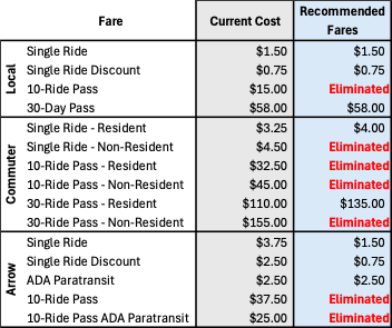
Fare Structure Changes
The new fare structure aims to simplify pricing, enhance equity, and improve the rider experience across all services. The plan aligns fares for Arrow on-demand service with Local bus fares, ensuring affordability and consistency. Additionally, underutilized multi-ride passes will be discontinued to streamline payment options and reduce complexity for riders. These updates reflect a commitment to making public transit more accessible and user-friendly while maintaining financial sustainability.
Key Changes to the Fare Structure
Arrow Fare Alignment: Arrow on-demand service fares will now match Local bus fares, making transit options more affordable and equitable.
Discontinued Multi-Ride Passes: Underutilized multi-ride passes will be eliminated to simplify fare payment and reduce confusion.
Streamlined Fare Options: The updated structure prioritizes ease of use, ensuring riders have straightforward and consistent payment choices.
Focus on Affordability and Equity: Changes aim to make public transit more accessible while balancing operational sustainability.
Please Leave a Comment
Learn more about Transportation 360, share your feedback, and subscribe to project updates by visiting roseville.ca.us/transportation360